Canyons of the Rio Grande
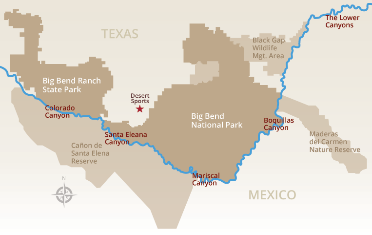
Ratings and days for trips vary with water level; call us for current information and recommendations. Permits are required for all river trips. See the BBNP website and BBRSP website for more details.
| Section | Put-in/Takeout | Miles | Days | Rapids | Description |
|---|---|---|---|---|---|
| Colorado Canyon | Rancherias/Madera | 10 | 1 | class II-III | Several small rapids; the only igneous rock canyon in Big Bend. Lots of fun for boaters with basic skills. |
| Contrabando I | Madera/Grassy Banks | 3 | 1/2 | Ledge Rock class II-III |
A mellow stretch of river traversing the foothills of Contrabando mountains. Easy access. |
| Contrabando II | Grassy Banks/Lajitas | 8.5 | 1 | Fresno Rapid class II-III |
Extends Contrabando I to Lajitas. |
| Santa Elena Canyon | Lajitas/Santa Elena Takeout | 20 | 2-3 | Rockslide Rapid class IV |
Considered by some the most spectacular canyon in Big Bend. Rock Slide is the most difficult rapid in the national park. |
| Great Unknown | Santa Elena Takeout/Talley | 47 | 4-5 | no notable rapids | A seldom seen stretch of river twists and turns past stunning vistas and abandoned river settlements. |
| Mariscal Canyon I | Talley/Solis | 10 | 2 | Rockpile, Tight Squeeze class II-III |
This limestone canyon forms the bottom of the “bend” in Big Bend. Difficult to access but worth the effort. |
| Mariscal Canyon II | Solis/Rio Grande Village | 18 | 2-3 | no notable rapids | Extends Mariscal I to Rio Grande Village, including San Vicente and Hot Springs Canyons. |
| Boquillas Canyon |
Rio Grande Village/La Linda | 33 | 3-4 | no notable rapids | The longest and most varied of the canyons in the national park. |
| Lower Canyons | La Linda/Dryden | 83.5 | 7-12 | Upper and Lower Madison class III-IV |
A boater’s paradise: rugged and remote. Given Wild & Scenic recognition by U.S. Congress in 1978. |
CAUTION! Summer heat and other extreme weather conditions may significantly increase the difficulty. Be aware of the possibility of flash floods, summer lightning storms and extreme temperature drops in the winter months. Always carry plenty of water and dress appropriately for weather and temperature conditions. Contact Desert Sports for current conditions.


